Friday 11 October 2019

Raymond Terrace to The Central Coast!

This was another big surprise. My initial thought of going this way was that I was going to put up with heavy city traffic and impatient drivers. This couldn't be further from the truth.

When arriving at Raymond Terrace I was planning on staying in a caravan park. I wanted something cheap as there were no free camps in the area. I did look down a few sidetracks and peered into the scrub a few times but there weren't many options that I would choose. I stopped at the rest area south bound at Twelve Mile Creek to make a few phone calls. The first was only open to workers as there are a lot of mines around the Hunter area. The second rudely told me that they don't accept tents, although their website said otherwise, and the third was the same as the second, just not as rude.

It was getting late into the afternoon as I continued pedalling south for Newcastle. There were some side roads just south of the Heavy Vehicle Weighbridge but nothing. On the opposite side of the highway there was an area, but right on the highways side, no thanks.

I thought that I would eventually find one but I was soon arriving in Raymond Terrace. The sun was hanging low and the next free camp was around forty kilometres away. There was the Shell at Hexam which was a nominated truck stop, but I knew from experience, as a truckie, there was no where really safe to pitch for the night. As I slowly rambled down the Pacific Hwy mumbling to myself all kinds of profanities I saw the motel where my family and I had stayed the previous Christmas. I wandered over and they had a room, and as a returning customer received a decent discount on that room.

So a motel it was again, settled in, showered and some dinner on I soon forgot about the earlier turmoil and settled in for a quick Facebook round up and phone call to the family. After all the day wasn't that bad, and although mostly on the highway I had a wide shoulder, smooth roads and deviations such as Karuah to ride through.

Morning came around and it was time to take a big breath and tackle the Newcastle traffic. I had a wide shoulder to the Hexam Bridge, a pathway over the bridge, then a footpath along side the Pacific Hwy/Maitland Rd. After the footpath ended there were sufficient bike lanes on the road's shoulder.

I had a route saved into my Garmin to help me navigate through Newcastle's streets. It had been years since I had spent my youth cutting capers in this town, coming down from Wingham on weekends. The route that was saved was taking me through quiet back streets, shared pathways and pathways through parks. Much better than the anticipated main road all the way around.

It was mid morning when I reached the start of the Fernleigh Track. The Fernleigh Track is the old branch line, now a well used rail trail, that runs from Adamstown in the central western suburbs of Newcastle to Belmont in Lake Macquarie to the south.

The Track started out it's life as a joint coal and passenger line in around 1880. It was going to be extended to Swansea but that never eventuated. It was originally laid between Belmont and Redhead, with further extensions happening in 1916, 1922 and 1925. April 1971 saw the last passenger train run along the rails and in December 1991 the line was officially closed.

Still today it sports a curved tunnel that is meticulously restored and looks as new as the day it was opened. It runs 181 meters under the now Pacific Hwy at Adamstown Heights/Highfeilds area.
The track is well used, and made me wonder if there was more traffic on the trail than on the roads...lol. Joggers, cyclists, commuters and walkers all co-existing together.

After stopping at Redhead for a late breakfast I continued south for Belmont. I took my time along here as I was just loving the shady cover of the trees and the quietness of the ride. If only I had made it to here last night...ahhh!

Soon arriving at Belmont the serenity was over, back onto roads, mainly main roads had me heading for the Central Coast of New South Wales. Surprisingly enough I was met once again with shared pathways and bike paths to keep me out of the flow of traffic. Many a roadie whizzed passed me, both here and on the Fernleigh Track with strange looks and hesitant waves. It was like they didn't know what they were looking at. What was this strange three wheel contraption that was loaded to the hilt? In the end they just smiled and shook their heads in disbelief. No weight weenying for me I'm afraid.

The views were wonderful. I had left the bush land of the trail to the scenic lake side views of Lake Macquarie. The pathways followed water views pretty much the whole way. I did, however, make a mistake and came out on an area of Pacific Hwy that had no bike lane or pathway. I did have a wide shoulder that was heavily littered in debris such as broken glass, bits of steel and the myriad of other things that fall, or are thrown from vehicles as they travel along.

Sick of this I regained my sense of direction and decided to leave this shit behind. I wandered down through Munmorah Sate Conservation Area. This once again took me through bush land then opening itself up to wondrous ocean views. I followed my way down through left and right turns until I came out at Budgewoi, and back onto the Pacific Hwy. But this time with two lane bike paths to escort me along.

Down through Toukley, The Entrance and Long Jetty I was accompanied by water views both sides of me. I hadn't planned to stay anywhere particular along here, my plan was to just ride until the day was over. There were no free camps but plenty of caravan parks. I just wanted to get close enough to Gosford as my plan was to catch the train into Sydney the follow day.

I ended up finding a peaceful caravan park at Bateau Bay that was clean, shady and quiet. This is just what the doctor ordered after a long day in the saddle. I set up camp, showered and then made my way to the local bowls club for a refreshing ale and a hearty meal.

I was happy with the day's ride and as I reflected my travels on Facebook I couldn't help but smile. It was one of those days where I had feared the worst but was rewarded in a magnificent way, views, peacefulness and some friendly chats along the way. What more could one want?

Cheers guys, and rise safe out there.


The peaceful coastal village of Karuah


The Fernleigh Tunnel


The siding of Whitebridge. The Fernleigh Track


Met by ocean views


Down through Munmorah Conservation area


Enjoying a nap


Tuesday 8 October 2019

Wingham To Buladelah!

Wingham is a small town on the Mid North Coast of New South Wales. It's history derives from the old timber days and over the years has moved into cattle. Wingham is also my home town, it is where I did most of my growing up. High school, rugby league, cycling, motor cycling, camping, I did it all there, even a little trouble.
The town still boasts a population of only around three thousand people and not a lot has changed since I have left. It still has that small town feel.

I had the absolute pleasure of staying with an old friend whilst here and it was great to catch up with other mates over the weekend's shenanigans. Getting out for a few beers, watching the old footy team play against long time rivals, and just kicking back and talking, catching up on the years since we all last were hanging out.

Monday morning came around all too soon and it was time to head off southbound once again. Instead of travelling the Pacific Hwy I opted, as usual, for a more subtle and relaxing approach to my day's route. I would head down through Burrell Creek to Krambach, then down to Buladelah where my plan was to free camp by the Myall River.

The bike repacked, a bit of a service done I was off heading out along Gloucester Rd. Unfortunately my excitement was short lived as the rear tyre deflated and I was on the side of the road fixing another flat. I had a small leak as I was heading to Wingham and thinking the problem was fixed...well we all know what thought did...
It appears that I had missed a small piece of wire that had lodged itself through the tyre.

Wire removed, tyre fixed I was on my again with a rejuvenation of my excitement. I hadn't been out this way for years, these areas were my old stomping grounds of years gone by. It wasn't long before I was about to head across the Manning River at Kundibakh. The old bridge is one we used to ride out to and jump off but it was no longer there. Instead a new wider concrete version stood in it's place.

The road was peaceful with minimal traffic and although there was no shoulder it felt safe with the few motorists that past slowing down and giving me room, many with a friendly wave. The road was still bitumen at this point and I didn't even know if I would ride on gravel. Passing through Burrell Creek and into Kramback it was still well before lunch. I stopped at a small cafe, had something to eat and topped up the caffeine levels.

Leaving the restful cafe I headed down Firefly Road and made my way south yet again. Although I had lived in this area for many years I didn't recall ever travelling this way before. The road was narrow but with no traffic, the scenery magnificent and the landscape undulating. Cattle wandered to their fences to check out this new found thing that was pedalling by, with many following down the road as far as they could.

It wasn't long before I was at my next intersection making my way up Wallanbah Road and then onto Bunya Road. Now my dream came true, gravel road. Bunya Road was narrow and wound it's way along the sides of foothills. The foothills soon turned into small mountains and I climbed, and climbed. Once I finished climbing I climbed some more for good measure.

The road slowly narrowed as it meandered along it's path. It wasn't long that it was just a single lane of road, and with no cars on it. This was the stuff dreams were made of, wandering serenely along a mountain road with spectacular views, and by the way...it was far from rough, the complete opposite.

Looking down over green valleys, shadowed by blue mountain ranges as a back drop I chose to walk a lot. Not because of the hills. Even though steep in parts they were more long and continuous, but very rideable. It was the scenery, I just wanted to walk and soak it in.

I came to a dilemma in the road. My planned route that I had mapped via Komoot and uploaded onto my Garmin wanted to take me another way. It wanted to take me via a mountain bike path that I eventually found the sign for. Now...the mountain bike trail was straight up and over. I had been caught like this before at Girraween crossing the the border from Queensland to New South Wales.

I was able to check Google Maps, and although there was no service I was able to see the road I was on, Manning Hill Road. It went around the mountain rather than straight up over it. Yes, it was still a continuing gradual climb but was far more enticing then pushing the bike and trailer up and over.

Ride a little, walk a little, I wasn't in any rush. I knew the time was passing by but there were so many options to camp it didn't worry me if I didn't make it to Buladelah. Actually it was the exact opposite, I was starting to look for a place to camp just for the sake of camping in such a wonderful place. After all, what was another day.

Up a bit further, around a few bends and I decided to step of and walk a little. After getting off the bike I heard a car and a motor bike coming my way around the bend. Now the road was rather narrow and I didn't want the driver or the rider, whoever was first, to get a surprise. I stepped down into the deep rocky laden drain on the side of the road to give both vehicles plenty of room. They came around the corner, saw me, slowed and waved, then continued on their way.

I stepped up onto the road. I hadn't pulled the bike down into the gully, I held it up on the roadside as I stepped down. As I stepped up again, a large rock rolled from under my right foot...and twang!!!
It was only several months prior I had an arthroscopy on my right knee. A torn medial meniscus removed, some gout and arthritis tidied up had the knee feeling new, until now.

I almost dropped the bike which would have landed on top of me. Anyway I struggled to regain my balance and eventually stepped up out of the gully. I was in pain instantly and immediately thought, and shouted, "Shit".

I still had a fair way to go to get to Buladelah which I wasn't worried about before. But now it was different. I had a new challenge, a new decision ahead of me. I walked for a while trying to walk off the pain. It did ease, but only slightly. Now the new dilemma...do I just find a place to camp and rest. I had an emergency ice pack in the first aid kit. I could just go a little further, find a place and set up. I could tend to my wounds and hopefully be OK in the morning.

Then the questioning doubt set in. I had no phone service, I was in the middle of nowhere, all day I had only seen a motorbike and a car. What if I awoke in the morning only to find I couldn't move my knee? I had plenty of food, but only enough water for one night.

It wasn't much longer and I had hit the peak of the mountain. It was mainly down hill from now, or at least I hoped. I bit the bullet and decided to continue to Buladelah. Pushing through to evening sounded a better option than being stuck somewhere. That's exactly what I did.

To my surprise my hope was founded. It was largely down hill. Yes there were uphills and it was here I felt the pain of the earlier injury. Whilst the hills remained rather light where I could lightly spin upwards all was OK. But as soon as they got too steep, it hurt. It was tough, because it hurt to get off and push as well.

The sun was well and truly going down. It was winter after all and it gets dark earlier. Onward I continued, slowly making my way to town with head light and tail light ablaze. Cars weren't an issue although a couple did pass my way. Eventually I was back on bitumen.

Not far to go now there were a couple of decent climbs that sent the nerve receptors into a panic. I made it up eventually and then the comforting sign of street lights. It wasn't long before I was in town and smelling the food being cooked at the local pub. I headed down to the free camp where I had planned to camp. Man oh man, talk about reminiscent of the crowd at a Big Day Out. It was jammed packed with every variety of camper van and caravan one could imagine. I did find a small bit of gravel available, but it looked like someone had emptied their lunch box on it.

I was pretty well spent. I knew I couldn't go any further to next free area so I did a quick google search, yes I had service again, and found a nice, quiet and cheap motel. Booked in, unpacked roughly and comfy I was straight into a hot shower. After that I unpacked the first aid kit and smashed the cold pack onto my knee. Some tinned baked beans and a couple of anti-inflammations tablets were dinner that night.

The next morning I awoke and after a rather restless night. It appears I may have made the right decision as it was rather stiff and difficult to get around. I spent an extra day at Buladelah simply because I wanted to make sure everything was alright. I went to the Chemist (pharmacy) and purchased a few more emergency ice packs. The motel manager was kind enough to give me a shitload of ice to use through out the day. By the the end of the day all seemed OK, and it was all systems go to head further south the next morning.


The Greater city of Garee


Looking out over Wingham


On my way out of Wingham


Just some of the variety of flora


The country side was spectacular


Manning Hill Road


Sun setting, still away to go

Thursday 19 September 2019

A Hidden Gem!

On my recent travels I saw many wonderful places. But one that took me by complete surprise was one road, Running Creek Road.

Running Creek Road connects Brooweena-Woolooga Rd to Kilkivan. Taking this way allowed me to miss Woolooga and the Wide Bay Hwy completely. Instead of tackling a major road with very little shoulder I was able to tranquilly meander a quiet road that was just a complete surprise. I'd in fact say, that this road was one of the highlights of my trip.

After being stuck on the side of the road for an extra day due to rain, I was able to get going with more than enough time to spare. I now only had around forty five kilometres to pedal. I knew I had some hills to traverse, but not knowing how many, and the gradients of them I was glad for the shorter day into Kilkivan.

After suffering Day Two Blues and getting an extra day stuck in a tent to get over myself I was excited to be on the bike as I made my way down Brooweena-Woolooga Road. From Maryborough-Biggenden Road this section opens itself up to be undulating and relatively cleared grazing land. But getting closer to the Woolooga end it starts to forest over, bringing in much needed shade from the warming Queensland sun.

The day started off clear, then clouded over as I began to ride. But only an hour after that clear blue skies were an amazing backdrop for the ever changing landscape.

After a late breakfast and coffee stop in a gravel pit on the side of the road I was not too far from Running Creek. It is here just after crossing a small bridge I began to work my way up through a mixture of thick patches of forest to isolated semi cleared farm land.

I crossed Running Creek once more after just entering the road and took full advantage of it's crystal clear running water. I had no idea what the day would have install for me, so taking the chance to fill up on as much water as possible was a given. It was so nice that after filling up on water I left the bike in the shade, ripped of my shoes and let them dangle in the nippy water. It was also a great opportunity to have a refreshing wash.

I was still finding my mojo at this point so walking the bike was a necessity. Although I do like to get off and walk every now and then just to have a stretch. But as I now began to climb the reasonably good gravel surface of Running Creek Road, walking was not just for stretching my legs.

The road essentially follows along the southern end of the area of Mudlo and Mudlo Nationl Park, so as I continued on my way I couldn't help regretting having the extra day stuck in the tent. There were so many picturesque camping spots along the way. I was so tempted to pull up stumps and spend just another day bathing in the beauty and quietness of this gem of a road.

As I climbed farm lands disappeared and gave way to native forest. Gums and ironwood, coupled with the local fauna of lace monitors, pheasant coucals, black cockatoos and countless of other varieties of wildlife, I didn't feel lonely at all.

After a couple of hours I eventually reached the summit. Stopping for a while to have some lunch, and a much needed cuppa, I couldn't help but soak in the peacefulness of the area. I sat in the shade for nearly an hour just listening to sounds and odours that enveloped my senses.

This was the first time the trailer that I was towing had been on a gravel road. To my surprise it towed effortlessly up and down the hills. It was a far cry from the previous week before leaving suffering the death wobbles behind me.

Along the top it was undulating, more like a large pump track more so than hilly.Views could be seen in all direction of the valleys below through the trees that littered the road side. One more light, but longish incline and then it was pretty much down hill all the way to Kilkivan. There were some gravel bends meandering back and forth across the side of the downward slope. It was a great feeling to just let it roll and enjoy the ride.

Eventually I made it back onto bitumen and followed the now acreage properties as I got closer to town. The road still remained quite and it was only as I pedalled into town via Tansey Road I saw my first car.

I have to say that this road is a cycling gem. I have ridden the Kingaroy to Kilkivan Rail Trail a few times now, and whilst I love it Running Creek Road is up there. The Kilkivan to Goomeri section is not an easy ride, especially for a loaded touring bike and trailer. But I have to say that Running Creek Road beats that section hands down.

Once on Running Creek Road it is only around thirty odd kilometres into Kilkivan. If you were a gravel bike enthusiast, or just someone who likes to get on their mountain bike and ride trails, this road would be the perfect day out. Great scenery, good road conditions and gravel most of the way would make this a perfect day ride. Or you could throw a tent on board and make a weekend of it. It's not hard, but has it's share of challenges. It's quiet with next to no traffic. What more could anybody want? I'll be out there doing this road again, it's a repeat offender as far as I'm concerned.

Cheers guys, and ride safe out there.


Remnants of an old branch line


The morning cloud eventually lifted to reveal clear blue skies


My kind of road

Wednesday 11 September 2019

Riding Old Grafton Road

Riding Old Grafton Road is something that I have wanted to do for a very long time. In November of 2017 I had the chance but had to call my trip short as the weather hammered every which way.
But all good things come to those who wait, and eventually the opportunity arose again.

After spending a day and a half on the New England Highway it was fantastic to finally turn off onto Bald Knob Road at Dundee. A chilly evening began setting in as I made camp in a secluded spot off the side of the road. I was hoping to have a fire but due to fire restrictions this was not possible. Instead I garbed on trackie dacks (tracksuit pants), thick socks and a few top layers to ward off the evening chill.

It's funny how quickly evening turns to night when you're camped out just on the eastern side of a mountain range. The stiffness of the chill began rolling in well and truly by the time I was preparing dinner, a much needed hot curry.

Well off the highway now the faint rumblings of trucks could be heard in the distance. The road I was camped beside was rather desolate and empty, so I only had the crickets and night birds to keep me company. With the exception of a few farm dogs barking in the distance, the night was relatively empty.

It was not late, but pretty close to zero degrees as I loaded myself into my sleeping bags, yes plural. I huddled down, beanie pulled over and drifted off to sleep. I awoke the next morning with a full bladder and no desire to leave the warmth of my bedding. But I had to brave it and get up and get going as today was the day.

Up, cold, with coffee and porridge on I was glad that I decided to put my winter riding tights on the night before. It was certainly not the morning to want to exchange warm clothes for fresh cold ones, and as the sun rose a little towards the mountain range's edge ice particles began forming on the heavy dew that was layering the tent fly.

Getting packed up and on my way by around 8:00 am it was still cold. Most of my riding was still covered by dense shade as the sun still hung lazily in low orbit above the horizon. But even with a very cool breeze, eventually I was able to comfortably strip layer from layer.

I was now on the Gwyder Highway heading East for Grafton. I only had about ten kilometres to ride before turning off onto Old Grafton Road. With very little traffic, and a lot of gradual declines the ride along here was a dream, and it wasn't long before I hit the road I had longed to see.

Once turning onto Old Grafton Road I just had to stop, take a breath and just soak in the ambience. No, seriously...this road had been on my bucket list for ages and now I was on it. I had ridden the Grafton end which is aptly named Old Glen Innes Road, but only the bitumen section. I used to enjoy riding it when I had my road bike, and it was a regular on my Grafton list of rides. But this end and all the way through was new to me, virgin lands waiting for me to conquer them and leave the dust settling in my wake.

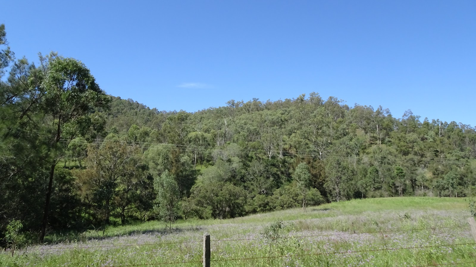
When first on the road it was open tablelands, but that only lasted a short while. The road then started to climb slightly with the surrounding bush land beginning to close in. I couldn't help myself from thinking, "If only I had pushed on another fifteen kilometres". There were so many secluded camping spots tucked away in amongst trees with no fences to be seen.

The bush became even thicker as I continued up the steady incline, bell birds now chiming in the background. The air got cooler and I was almost ready to reach for an earlier peeled of layer to rug up once again. It wasn't long before I saw the sign I was waiting for, "Steep Decent", now it was all down hill for the next two days, or was it?

This is the funny thing about planning everything on computers without any real knowledge of the area. I considered that it being higher at the top than it was at the bottom it would be all down hill.

After the Steep Decent sign it 'was' a steep decent. Zig-zagging down the mountain side with tight hair pin bends made one want to let the brakes go and go with the flow. But this couldn't be done. On one side there was a sheer cliff face and on the other was a sheer drop. Added to this was a fine film of sandy gravel covering the road that had been washed down in recent rain storms. This made the tyres loose on grip, and with the trailer on the back pushing hard, some corners were underwear changing stuff. I had to stop half way down and give the brakes a quick adjustment and let them cool off so we would be right to the bottom.

The decent continued and a small creek with crystal clear water appeared through a small reprieve in the down hill run. I pulled over to the side and filled up my nearly empty water bottles then continued on. Down the hill we go go again.

I kept thinking to myself, "Man, this will be great like this all the way to Grafton". I knew that there was a mixture of terrain at Grafton's end, but my ignorance of this end was to be short lived. I was about to be introduced to the 'real' Old Grafton Road.

Continuing down hill past the Mann River Camping Grounds I crossed a small bridge and hit the dirt. When I say hit the dirt I meant hit, I hit hard. Waiting on the other side of the bridge was the dirt section. From the bridge it was a sharp incline the snaked around some rather blind bends. But what hit the hardest was the condition of the road. Deep corrugations up to 15 cm deep greeted me with a loud "crack". The noise of the bike hitting this badly degraded section of road made me think something had broken.

The road was so bad, and steep that I had no choice but dismount and push the bike up around the corner. A car coming the other way stopped and asked if I was OK. I was and she kindly informed me that the road got worse, much worse.

Now pushing the bike up the sharp, rutted incline I found a relatively flat spot off the road where I could catch my breath and check things over to see if anything had broken. All seemed good and I took a large drink, straddled the bike and began to pedal up the hill. It was impossible. The ruts were so bad that that it was just so difficult to pedal over them. Along with the bike and trailer wheels getting caught in them, the tyres just did not want to grip.

I eventually made it to the top of this first climb as the road drop downwards once more. It was still an insane amount of effort required even to ride these corrugations on the flat or down hill. This continued on for, I don't know how many kilometres. Most of it being walked, and what downhill runs I did ride I was confronted with bike cracking ruts. All I can say is that Kona make one tough bike in the Sutra.

After several hours of walking, bone jarring flats and the odd down hill run I couldn't understand why one would be going down a mountain range and have so much climbing to do...and the road just continued to get progressively worse. Ahh, the bliss of ignorance being darkened by reality.

I don't know just how many kilometres I walked until the road appeared to smooth out a little. I appeared to be in a bit of a basin where it was more undulating than it was massively hilly. The road smoother, the hills easier the day started to show signs of revival. I was completely exhausted by now so it was relieving to say the least to have this change.

I caught up with a local farmer setting his cows back out to pasture after the afternoon's milking. We had a brief chat and bid g'day to each other. Not long after that I was surprised to see a stretch of bitumen. Could this be the end of the dirt? Had I travelled further than I though? No, it didn't last long, and at the end of the bitumen there was a sign which read, "Degraded Road Ahead Next 60 Kms".
What, you're kidding me right?

Actually the road was rather pot holed but the corrugations were not as much as a problem. The corrugation problem earlier was also enhanced by the afternoon sun setting and casting long shadows across the road. This made it impossible to navigate the ruts as they couldn't be seen through the shadows of the trees.

The road still had it's fair share of hills but at least they were smoother and ride-able. I had stopped trying to push the pedals hard up hills to attempt to get up them quickly. I now, through sheer exhaustion, found my slow mojo, spinning lightly and only topping out at around four to five kilometres per hour. It wasn't much faster than walking, and it was easier in the end.

I was now seeing the Boyd River as I progressed. My original aim of Dalmorton was now not a possibility. The sun starting to dip behind the mountains made sunset that little earlier, the cool evening air was setting in and it was time to start looking for a camp site.

I eventually found one. Off to the side of the road a ways and along the edge of the river. I ducked down a rough dirt track to have a look at things. I found a beautiful little spot tucked in behind shrubbery and well hidden from the road above. Not that it mattered too much, traffic was not an issue.
However on one of my earlier stops for a drink and rest I was crossing a small one lane bridge. An Izuzu D-Max came the opposite way. I stopped and chatted with the elderly couple who were camped up at Glen Innes. Funny thing was that they were from North Bundaberg. It certainly is a small world.

Fully decided on the camp site I began unpacking. There seemed to be plenty of greenery around with damp patches common on the ground. I could only assume that there were no fire bans in place and collected a good load of wood as well.

After setting up on the edge of dark I headed to the river on a rocky cropping and collected some fresh mountain water for cooking and filling up the water bottles for the next day. The billy then put on, and with my usual afternoon cuppa tea as I set about lighting the fire.

It was now dark, cold and the dampness of the night air was settling hard. The dew was that heavy that I had to put on a wet weather jacket. The dew doesn't matter when you can look up and see so many stars that you're left breathless.

After dinner it wasn't long before I hit the fart sack. I have to say that this was one of the best night's sleep that I had had. Chalk it up to sheer exhaustion.

All I can say is that the next morning came around way too soon. After the tough seventy-five kilometres I endured the previous day, the night past into morning swiftly. I didn't wake until what I thought was dawn. But because I was camped deep within a mountainous crevice it was much later than I thought.

The heavy dew from the night before had saturated the fly of the tent and whatever else was left out overnight, which luckily was not much. It was a chilly morning yet again, the sky was blue and clear, and with little wind and faced with such tranquillity I reluctantly set about packing up what was left.

I skipped breakfast. The massive feed from the night before still lay in my gut. I kept my usual on standby, some bananas, muesli bars and a tin of mushrooms. Of course I could not skip the morning heart starting jolt of caffeine.

Packed up and eager to tackle the next eighty odd kilometres into South Grafton I set out on my way. Back up onto the road and pedalling gently until the warmth began returning to my body. There are so many beautiful sections along this road, but the approximate twenty kilometre ride in Newton Boyd was my favourite. Following the lazy Boyd River just made me want to stop and take stock of it's rich green sidelines, a shade shrouded wonderland.

Not far along and I moved over for a motorcyclist to pass. But he stopped and we chatted for at least and hour. Unfortunately I had put myself under pressure by putting forward a timetable along this stretch. I wanted to get to Grafton to rest for a couple of days. Hind sight is a wonderful thing, isn't it?

I eventually reach The Old Grafton Tunnel, a tunnel that had been hewn straight out of the rock. It is an historic icon that has stood the test of time. I had to stop for some photos and of course get the DJI Spark out for a flight. It was here I forgot the golden rule, and was too concerned with watching my phone screen rather than the drone itself. Crash, a broken propeller and a limping drone. That was enough of that, I dusted it off, packed it up and set off for the next stop.

Now at Dalmorton I stopped and looked at the relics of the old township. I had planned to ride down and check out the camp sites along the river where I was aiming for the previous day. But my earlier friendly chatting had taken it's toll and I opted out.

What started out as bullock trails in the early 1840's was now this one hundred and sixty odd kilometres of road. It was transformed into a road around twenty-five years later, and used as a connection route between the New England Ranges and the Clarence on the coast by Cobb & Co.
The tunnel was part of this 'modern' upgrade and was carved straight from the rock above. It's only a short tunnel, with a clearance of just over three meters.

Dalmorton kicked off as a Gold Rush town in the mid 1800's. At it's peak it accommodated up to five thousand people with thirteen pubs in full swing.
All that remains today is the remnants of history, an old butcher's shop, one other building and what appears to be a still operational camp for schools or large groups. The river is on the eastern side of town with camp grounds easily accessible.

The road from Dalmorton certain put forth it's challenges once again. Although the hills may not have been as steep as the previous day, they were long and drawn out. But the road was much smoother, and that had to be a bonus.

Then coming into Buccarumba where I crossed the Nymboida River, remnants of old bridge pylons could be seen littering the river. I'm unsure from what era these came from, but there is quite a few. There's also a camp site here as well. Again, on the eastern side of the road and on the northern side of the river. The grass was extremely long when I went through, and it didn't appear to have too much shade or shelter. I had a rough plan of camping here, I'm glad I didn't. Although in all fairness I didn't ride down the tracks and investigate any further.

There were some good long flats now and I was tempted to put the hammer down and push hard to make up time. But the Grafton end of this road I knew rather well so resisted the urge. I still had plenty of long climbs to do before joining the Gwyder Hwy.

Now leaving the river as company I drifted into open farm lands. The road was still well shaded and the afternoon sun started to drop in the sky. I was still at least thirty kilometres from South Grafton but I was sure that the bitumen wasn't far away, then psssstttt...yep a flat. This was the first for some time. The bike and tyres had help up well, the tyre liners seemingly doing there job, and considering the road I was riding, I was surprised a puncture didn't happen earlier.

Bike upside down rear wheel off it didn't take long to fix. Actually when touring the flats never take long to fix, it's the loading and unloading of the bike that takes the time. Loaded up and on my way it was only another kilometre or so when I hit the bitumen at the Grafton end. WHAT!!! The flat couldn't wait, it just couldn't hold off...lol It would be several days later when leaving Grafton I would realise that it was here that I lost my good Anker solar panel. It must of fallen out of the straps on the front rack when flipping the bike.

Now on the bitumen, I was familiar with this end. When I stayed in Grafton and had my road bike this was a popular route for me. Many hills both ways, it was a good thirty kilometre ride each way from the Gwyder Hwy. I so wanted to go hard as there were plenty of long down hill runs and long sweeping flats. But I also knew there were still plenty of long steep climbs as well. It took a lot to hold back the old MAMIL within me.

The sun was well and truly hanging low in the sky and with it descending below the mountains, darkness was fast approaching. Lights ablaze I kept going. I knew that it wasn't far now and I had a hot steak and a cold beer waiting for me. I came around the last bend and up a slight rise and there it was, the Gwyder. It was now only a short pedal into South Grafton, most of which would be on a shared path way.

It was a long and hard two days. I think next time I do this road, and there will be a next time, I will take my time. I think if you took five days to do the Old Grafton Road you would be less fatigued and see so much more. It is a must do ride and would be perfect for bike packing on the mountain bike, far more than a loaded touring bike with trailer.

There are many little drop downs into the river, some side tracks and spectacular views all the way along. Do yourself a favour and put this road on your riding bucket list, take your time and just soak up the serenity.

Cheers guys, and ride safe out there.


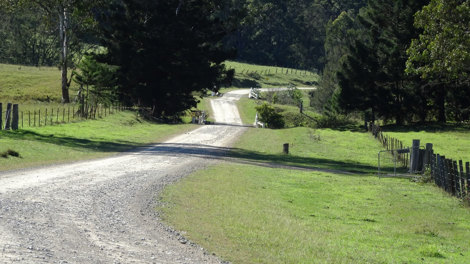
Long downhill runs with continual hairpins meet you at the beginning of The Old Grafton Road


Eventually on the dirt. Let the torture begin


But the scenery is contiually magnificent


Now following alongside the Boyd River


Not much remains of the once thriving gold rush town of Dalmorton


The Old Grafton Tunnel still standing strong.


Calm waters make for a perfect reflection shot


A little tunnel history


The last bridge before hitting the Gwydir Hwy into South Grafton